project focused on sustainable land use planning.
Find out more about us >>

Action Alert: Send your gratitude and other comments on the Evacuation Preparedness Plan to Calaveras Ready by August 31
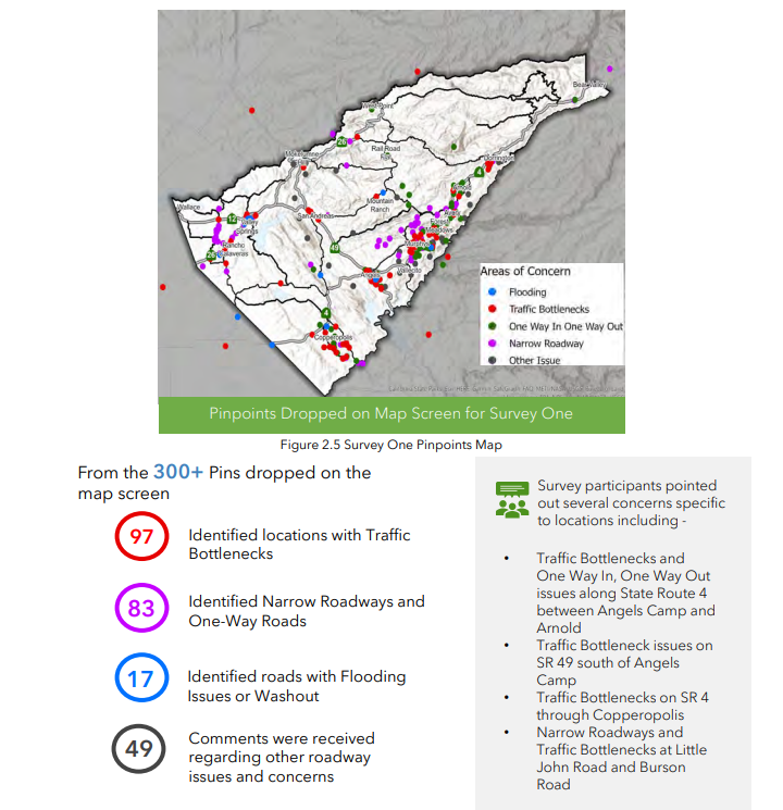
Calaveras Ready recently completed the Draft Calaveras County Evacuation and Access Needs Assessment and Preparedness Plan. The consultants working on the plan asked residents to identify locations on their most likely evacuation routes where road capacity bottlenecks, landslides, flooding, or other conditions could impede their evacuation. Over 200 people responded, identifying over 750 such impediments to their evacuation. These were consolidated into over 375 projects primarily along Highways 4, 49, 12, and 26, but also on some County-maintained roads. The plan identifies roads critical to emergency evacuation and lists State and Federal funding available to implement the evacuation route improvements.
We hope that Caltrans, Calaveras County Public Works, the Calaveras Council of Governments and others will work together to secure the state and federal funds available to complete these projects. You can review the draft plan and send in your comments and thanks to Calaveras Ready through August 31 at https://calaverasready.com/.
In your comments you could mention some of your favorite parts of the plan:
Chapter One does an excellent job of dividing the County into functional evacuation zones and identifying the relevant demographic, critical facility, and road information for each zone. This familiarizes readers with a base of common facts used in later parts of the plan.
Chapter Two explains how Calaveras Ready consulted public officials and members of the public in preparing the plan. These consultations and the on-going transparency of the process add weight to the plan and increase public confidence in the findings. Thanks are especially deserved for the two maps identifying the over 750 pins dropped on the maps by survey respondents identifying road hazards along evacuation routes. These help to highlight how the communities of Copperopolis, Valley Springs, and those along the Upper Highway 4 corridor are all in great need of evacuation route improvements. We hope that the geographically broad scope of the problem will help to galvanize local government support for action.
Chapter Three accurately identifies high and serious local risks associated with wildfire, flooding, and debris flow.
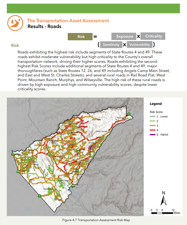
Chapter Four frankly identifies the great vulnerability of communities in County Supervisor District 2 to hazards from wildfire and landslides. It also shows the risk that hazards pose to critical roads and to critical bridges along the Highway 4, 49, and 26 corridors. Thank you for the illuminating maps depicting these risks and vulnerabilities.
Chapter Five identifies priority corridors for later inclusion in an evacuation plan, as well as the percentage of traffic leaving the County borne by each road. The map on page 70 does a good job of communicating these facts. We hope that Calaveras County will include these critical evacuation corridors in an amendment to its General Plan.
Chapter Five also reveals that people are not sure how they will be alerted to the need to evacuate and how to find out where to go in an evacuation event. Critical facility operators and first responders indicate that there is a great need for community education, for additional staff and funding, and for the improvement of evacuation routes, especially Highway 4.
Chapter Six places the necessary projects into functional groups. It identifies projects to create defensible space and remove hazard trees on specific County and State roads. It identifies projects to reduce flood risks on County and State roads. It identifies six priority programs and identifies State and Federal funding available to implement them. We especially appreciate the detailed effort in Chapter Six to identify the ways to implement the recommendations of the plan on the ground in our communities.